Today the Auckland Transport board meet again as a whole for the first time in two months. AT note:
Members of the public are welcome to join the meeting via Teams. Please note, due to technical difficulties, the video feed will be unavailable. However, attendees will still be able to view the meeting presentations, and the audio will still be accessible, allowing attendees to listen to the proceedings. A solution is being evaluated with the aim of restoring video service for the 18 December 2024 meeting.
As usual, I’ve taken a look through many of the papers and have highlighted below some of the things that caught my attention.
Closed Agenda
The closed agenda has previously been the location for many of the most interesting papers to the board. Positively, many of these have been pushed to the public sessions in recent times but there are still a few interesting items
Standing Items & Extraordinary Finance Items
- Analysis on public transport passenger costs
- Approval of adjusted operating and capital budget due to National Land Transport Plan funding implications
Board Committees Update
- Fare Structure
The fare structure paper is probably the most interesting here. Are AT looking to make changes to the how our fares work – there are certainly some improvements I would love to see – or is this just related to the annual fare review?
Potential implications of the new speed rule for Auckland
Early last month the Minister for Transport Speed announced a new rule requiring blanket speed limits to be set and that changes that have occurred over the last few years be undone. As the title suggests, a paper to the AT board gives an indication on what the implications of this are.
It notes that “AT’s Safe Speeds Programme has set safe and appropriate speed limits on more than 3000 roads since 2020“.
They say the exact details of the new speed rule are yet to be released but initial estimates are that around 1,800 roads, or about 57% of all roads that were changed, will be required to have speed limits increased again by 1 July 2025. This is mostly going to be local streets surrounding schools.
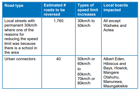 In the cases of around schools, new variable speed limit signs will need to be installed but only outside the school gates and only operating at the start and end of the day.
Doing all of this isn’t free either with AT expecting it to cost nearly $25 million, for which no funding has been provided by the government.

The costs could increase further as AT also say that they will need to reassess any infrastructure impacts from the reversals – which suggests things like speed tables might need to be removed.
Those costs will quickly be dwarfed by the economic and social impact of any additional deaths and serious injuries that come as a result of the changes. AT say they will be putting in place a plan to monitor the impact on the changes, including how speed and journey times are impacted.
I know there are dedicated people working in this space within AT but there are also many (senior) staff who support this change and I can’t help but think that if the situation was reversed, they’d be pulling out all the stops to delay change as much as possible.
Carrington Rd Preferred Option for Approval
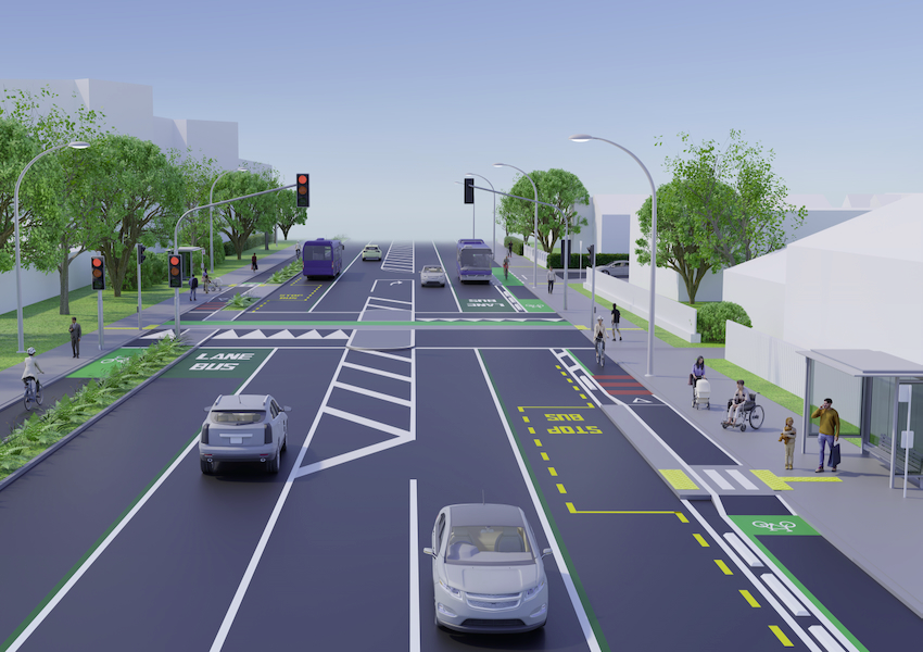
Last year Auckland Transport consulted on plans to widen Carrington Rd to accommodate the expected population growth in the area as a result of the Unitec site development and to improve travel options. The plans included dedicated bus/transit lanes and protected cycle lanes as well as other safety improvements.
The board are being asked to approve the business case for the project and to proceed with detailed design and construction.
AT say the consultation showed general support for their preferred option which is expected to cost up to $105 million and has a benefit-cost ratio of 4. That is within a $120 million funding envelope approved under the Infrastructure Acceleration Fund. They also say “there may be a requirement to incorporate third party funded upgrade works (e.g. utilities) within the project delivery scope“.
Public consultation on the short list options in 2023 showed that over 60 per cent (of 365 respondents) supported an option which includes bus or transit lanes in both directions and a one-way cycleway in either direction, and 60 to 80 per cent supported the proposed new or relocated crossing points.
The preferred option (see Attachment 4) accommodates the expected future growth and has the following key features:
- Approximately 7m of widening through land acquisition along 1km of residential development frontage.
- New special vehicle lanes – bus or transit lanes.
- Maintains a one-way cycleway on either side of the corridor.
- Maintains one general traffic lane in either direction.
- Three new traffic signals, required to be provided for the development for access and safety, at the Gate 1, Gate 3 and Woodward Road intersections.
- Two new signalised crossing points.
- A relocated and more direct Northwestern Cycleway crossing point.
- Widening of the Mt Albert Rail overbridge for active modes (to be confirmed in design stage).
- Bus stops consolidated and located closer to crossing points.
- New landscape and streetscape plans with 2-1 tree replacement.
- Rain gardens and improved stormwater management.
- Side road entrance treatments including raised platforms.
It’s interesting that they note that the widening of the rail overbridge is still to be confirmed. Last year they say it cannot be easily widened for vehicles but later in the paper they note they will also investigate this for vehicles in the next phase.
AT included this table highlighting the results from the business case. One thing that stands out to me is that despite the rhetoric around mode-shift, the biggest single increase in users will be more vehicles and despite a 49% increase in vehicles between the baseline and the recommended option in 2031.

Business Report
The business report has a number of items that stand out:
Some positive news around public transport:
- Accelerated Ferry Programme nears completion: Gulf Harbour ferry services returned to full schedule in September, with uplift in customers observed immediately. Daily patronage has almost doubled from approximately 200 to just under 400, with a peak over 500 in early October.
- Halfmoon Bay is the last route to return to full service and will do so in November, five months earlier than anticipated. This will complete the accelerated ferry training programme.
- Encouraging adoption of the 7-day fare cap: since we introduced the 7-day fare cap at the end of July, over 20,000 Aucklanders have benefited from the cap.
- We have recently promoted the fare cap to remind Aucklanders that once they reach a $50 fare spend in a 7-day period, all following travel is free. Our aim is that this encourages more public transport trips and increases patronage.
- Expanding Fareshare scheme: 20 organisations have signed up to the scheme, with over 800 employees on-boarded so far. In September the Fareshare team exhibited at the Climate Change & Business conference, attended by around 350 organisations. We’re now working on the leads gathered at the conference.
- Northwest bus network changes: the WX1 and 11 services (introduced in November 2023) have reached a milestone of 1.5m boardings since go live. AT is working with New Zealand Transport Agency Waka Kotahi (NZTA) to make incremental improvements; additional bus priority is expected in November 2024 at both Triangle Road and Fred Taylor Drive to provide improved reliability for bus passengers.
This sounds like an interesting and useful piece of work but surely the big risk to it is getting funding prioritised to be able to do something about the risks identified.
Landslide Resilience: The Science and Sustainability Group have developed a framework to predict and identify locations on the road network which are susceptible to landslides. The framework was developed using the 2023 flood events data and was applied to the AT road network using Artificial Intelligence (AI) / machine learning. This leading approach will enable works to reduce landslide risk, increasing the resilience of the network and support adaptation planning. Auckland Emergency Management team is interested in the system and the ability to connect to live meteorological data will be investigated.
Dominion Rd Flyover Removal
There are three public presentations to the board on the agenda
- Wellsford footpaths – Geoff Upson & Colin Smith
- Overnight parking and wider city discussion – Viv Beck
- Simplify the intersection of Dominion Road and New North Road – Graeme Easte
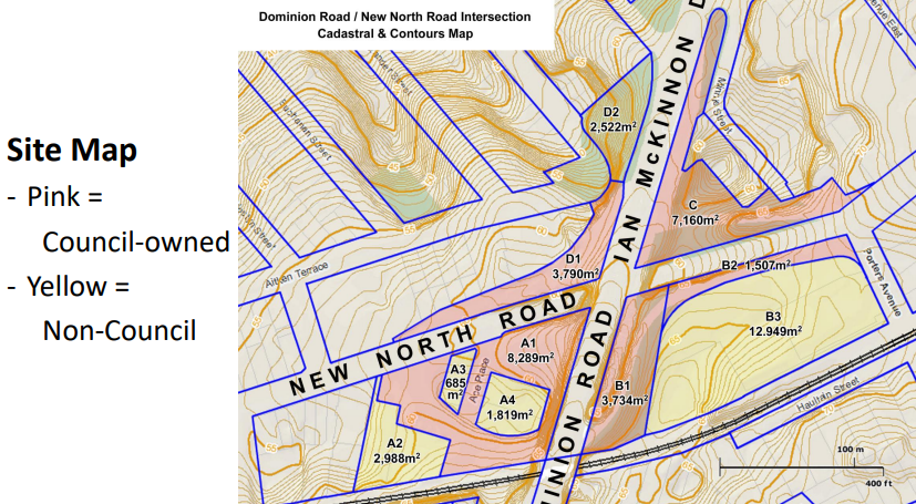
The presentation for last one, by former Albert-Eden Local Board member and regular reader of the blog – Graeme Easte – has been included in the agenda and is an issue we’ve long supported, removing the Dominion Rd flyover.
He notes that by removing the flyover it allows for the return of over 24,000m² of land for development and an estimate eight years ago suggested that was worth nearly $100 million – however it would be worth a lot more now.
 Graeme suggests that the money from the sale of this land could be used to progress level crossing removals along the Western Line while the land itself could provide thousands of new homes and jobs close to the city.

There are a few of other papers on the agenda, is there anything that stands out?

 Processing...
Its a shame that at the same time we are hoping to get rid of one ghastly flyover, another is being built in Pakuranga.
On Carrington Rd, and your comment, “One thing that stands out to me is that despite the rhetoric around mode-shift, the biggest single increase in users will be more vehicles and despite a 49% increase in vehicles between the baseline and the recommended option in 2031.”
At least they admit it, I suppose, although their outdated modelling means they are won’t be showing the full impact.
Council; they’re no excuse for letting AT continue with their shit planning methodology. This didn’t need to cost $120m. It could have cost under $20m, and reduced traffic volumes significantly throughout the whole area.
AT’s living in 1970, but Council? Willing to be undermine their own plans. Really poor governance.
Also, advocacy bodies need to step up. Stop undermining climate action by lending support to moar road projects.
Very supportive of removing the Dominion Road flyover as a nearby resident.
The development opportunities so close to Maungawhau station are obvious, but redesigning the roads around there gives us the opportunity to make the bus lanes along New North Road continuous.
Currently, buses heading into the city in the morning peak need to come back into the single general lane for the underpass, get cut off by and stuck behind cars merging onto NNR from the flyover, then return to the bus lane. When the general lane gets backed up as it often does, this 500m stretch can take multiple minutes, bunching up buses and slowing down journey times.
This bus lane being continuous and getting priority will increase capacity, meaning AT can increase frequencies and more PT users move into the area between Kingsland and Eden Terrace (and hopefully Kingsland itself if we can upzone it!).
Removing the flyover is a no brainer that is worth the cost and disruption.
The only issue I have with it is that at some stage AT will surely realise that Dominion Road buses should go via Ian McKinnon Drive (as light rail would have), so removing the flyover will introduce another delay to buses.
Before Ian McKinnon Drive, Dominion Rd stopped at New North Rd, with trams running between. If the Dom Rd LRT were built, it could do similar, and connect with CRL where NN Rd passes Mt Eden station
I’m kinda wondering about the bad shape factors of that left-over land though (that’s developer speak for land that is funky shaped and/or too-thin to develop easily). And some of those are sloped areas too. You’d probably need to consolidate with some adjacent land to get some good building plots. Not saying I think it’s a bad idea, but it may have some fishhooks in actual implementation…
Also, even without considering our “what does the traffic model say?” approach to intersection design, that map above shows no intersection widening at all – it even narrows down a bit compared to the approaching midblock. Unlikely. Not unless you want to go without walk and cycleways. If you do that, then even before you add extra turn lanes to make the modellers and politicians happy, you need more intersection space. Even more yet if you want to have a proper PT interchange there (even a neighbourhood size one).
It’s funny how AT are pushing fareshare and yet they don’t even have it for their own employees.
How much are ratepayers willing to chip in for AT employees to have cheaper fares? Please write in to the Mayor.
I would think most ratepayers like myself, would be very happy for all council and AT employees to use PT, and would rather have that usage (along with active modes like EBikes), to be subsidized than ‘free’ parking or company car perks
Getting AT to consume one of their key ‘products’ – PT, is how you get real world improvements
Industry term; eat your own dogfood (https://en.wikipedia.org/wiki/Eating_your_own_dog_food)
“Getting AT to consume one of their key ‘products’ – PT, is how you get real world improvements”
I think Inside Out was mostly referring to the “damned if you do, damned if you don’t” approach some of the public and the media have to Council staffers getting anything “subsidised from OUR rates”.
AT head office should all be made to use PT to get to work. If it isn’t good enough for them then why would it be good enough for anyone else. I frequently get the impression that no one in their head office uses PT as if they actually did, they would fix the issues. Minor fixes such as moving where 3 carriage trains stop (I have to walk most the way along the platform at my local train station if it is a three) and introducing a bus hub in town are actual things that need to be tested by people. Theory just isn’t good enough in many cases and AT staff need to get out on the network to try out the user experience. Not that difficult. Even cycling to work would be beneficial as it would show AT how their cycling network is flawed. 4-5 day office work weeks also needed…
“AT head office should all be made to use PT to get to work. If it isn’t good enough for them then why would it be good enough for anyone else. I frequently get the impression that no one in their head office uses PT as if they actually did, they would fix the issues.”
Well, they had a CEO who didn’t have a car for what, 5 years? Didn’t change the culture. But yes, the basic sentiment is right – except that “making” anyone use PT is bad practice (as well as illegal in work contracts) so it’s more about making it actually, you know, work well…
Very few AT employees use a car to get to work.
Some cycle, some walk, some use motorcycles, most use PT.
All use one or more of key AT’s “products’.
AT staff shouldn’t be made to take PT. But they shouldn’t have any carparking funded or provided, and they should have discounted PT.
“I would think most ratepayers like myself, would be very happy for all council and AT employees to use PT, and would rather have that usage (along with active modes like EBikes), to be subsidized than ‘free’ parking or company car perks”
AT does not have company cars or staff car parking. It only offers free parking to staff for bicycles, scooters and motorcycles.
I guess AT is only as slow moving as most other things in this place. Eventually we will have a CRL, and join the modern world, with a real subway system, but we will still be behind on apartment living.
It is a massive fight against the 1970s, and unfortunately most of those in power are still baby boomish, and therefore addicted to motor normative, hetero normative, and general generational lack of foresight.
I heard on the radio this morning that the Council with Sport NZ, is doing some cool events to encourage kids, and hopefully parents, to value play a little more.
(I declare myself an anti STEM, only because PLAY is far more lacking these days, and Engineers are very uninteresting persons, until they go through a proper crisis and start drawing some nice art).
Of course we need engineers to make sure everything sticks together, and doesn’t fall down, but with the Infinite Pyramid and another semi White Elephant in Onehunga (which I think is being saved from dereliction at least), our city remains un-naturally pro housing and anti apartment living, which is against even the historic value of cities, is that they draw the population to the genius of shared living. This is basically why we are forever playing “why can’t we be Melbourne” which is of course a reasonable notion, but sad in the way that we only aspiring to such a modest neighbour, and not to be a true citadel in the modern world, which with climate change we undoubtedly need to prepare to become.
In any case, having witnessed a couple of AT Board meetings in person, I am happy to miss the next few, as they are hardly colourful affairs, and often seem to be dominated by damage control (public relations is probably the official name).
bah humbug
As an artist and engineer myself, you couldn’t be more wrong if you tried.
Now that light rail is dead won’t we need the Dominion Road flyover to build the Central Motorway?
Hear me out: When we do that Dom Road Motorway, we turn New North Road into a SECOND west-east motorway (I mean, SH16 it too congested, it’s time to think bold thoughts!).
The Benefit-Cost-Ratio for the interchange gets even better!
Yes and while we’re at it we need a humongous elevated motorway from Herne Bay to Mechanics Bay so Ali Williams can get to the heliport faster (unless the council let him build his own).
Also needed: motorways from Eketahuna to Dannevirke, Temuka to Waimate, and a gigantic tunnel to Wellington airport …. Oh, wait
Maybe that western railway line could be paved as an alternative road out top New Lynn.
Supporting efficient PT and active modes does require investing in space for those on what is currently a 2-lane road. The driver for this (pardon the unfortunate word) is a new town being built on Wairaka Precinct (Unitec), with two signal intersections for their car users (as few as practical, but still quite a lot). A real boost to cross-town bus passengers is the most important objective. Walking to bus stops with reliable services will cut the number of extra car trips, with cycling also helping. It doesn’t come cheap.
When a completely new suburb is being built in a location as well-connected as this one is (for biking and public transport), the last thing you should do is create a wider road. It is fundamentally unsafe to lengthen the crossing distances for people on foot and bike. The two ends of the road will now become pinch points… The Point Chev end desperately needs all the roads to be put on a diet, not have a widened road feed into it.
AT’s design uses road widening on Carrington Rd, not because it’s the best solution but because AT’ engineers refused to step up. They refused to learn how to reallocate space while changing traffic circulation patterns, with low traffic neighbourhood and timed access for private vehicles.
Council should have replaced board members until the organisation actually delivered on the TERP. Instead they’ve sat by pathetically while AT created and promulgated myths about what they can’t do.
Cosmic. Siri literally just read the Dominion Rd flyover removal heading just as the train I was on went under and through it.
The school speed limits is an easy one – simply have a school bus parked outside with its signs displayed, because the speed limit past a stopped school bus is 20 kmh. The road code doesn’t state that pupils have to be boarding or alighting the bus, or the size of the bus.
I like the civil disobedience part of that, however, if people still speed (and who is going to come and enforce that 20km/h limit?), then having your sightlines blocked by a bus will be really dangerous.
Apart from the fact that this would create a record-breaking “under urgency” change of our laws if any school actually tried this, the whole point of good traffic calming is that it applies not just at one point… or do the kids magically teleport from home to that one crossing location at the school?
I know you were just kidding.
Sadly, our minister is not. He’s deadly serious that higher speeds are more important than a few lives.
I’ve just returned to Blighty after a few days in Antwerpen. Now there’s a city going back to the future.
The whole place has been dug up to install tramlines with no complaints from anyone and bicycles and pedestrians safely intermingling, something that cannot be said about much of Western Europe where cyclists are almost bigger menaces then cars at times (and I’m a cyclist too before you say anything).
Looks like the Great North Rd Improvements have been reconfirmed which is good news following a bit of conjecture as to whether it would be delayed again
Be nice to get some cycle protection along Carrington Rd, now I’m using it for biking from Mt Albert Station to Unitec. Some close passes at present or just feeling really unsafe esp around the bend with just painted line. wow.