Discussion of another harbour crossing has been in the news a lot recently as a result of Mayor Wayne Brown pushing for a bridge from Point Chev to Birkenhead. While I believe his proposal is bad, at least some of his reasoning behind his push for a bridge is correct. As reported by Stuff:
However, the Mayor wants to scrap that idea too, believing the tunnel will never happen and is proposing a bridge from Meola Reef to Kauri Point, which he believes would eventually pay for itself.
“It starts with the fact that the tunnel is a bad idea,” Brown said.
“We’ve got experience with tunnels in Auckland with the CRL (City Rail Link), they always cost twice as much as they say they’re going to cost. And they said that one was going to be $17 billion which means $34 billion which is the entire budget for transport in New Zealand for 10 years.
“It goes from a traffic jam on this side to the same traffic jam on the other side. So it doesn’t solve any problem, because the bridge isn’t congested at all.”
The proposed tunnel would go from Northcote on the Shore and link up with the motorway system in central Auckland and the Mayor doesn’t believe this would alleviate traffic woes.
“Having a tunnel doesn’t help that at all. And so I’m looking at what is wrong with what the offer is, then is there an alternative?” he said.
…..
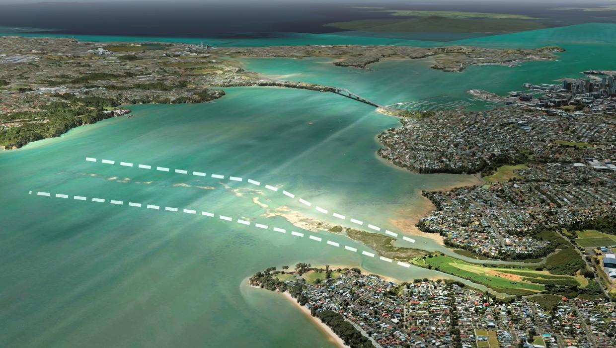
“It goes 80% across the Harbour, the reef at low tide, and you can either put a causeway or even a whole series of low bridges,” he said.
“No boats go underneath that, because they’d go aground. And then you have a short bridge to the other side that’s way cheaper.”
Here we go again…
The current proposal reminds me of an image from one of the older motorway plans, which was brought up again by a former ACT candidate in 2018. In other words, this is not the first time people have looked at the map and been tempted to draw this particular line, regardless of the actual terrain.
The recurring flaw in this idea
The key problem with this proposal is highlighted (in the aforementioned Stuff article) by Councilor Richard Hills: what happens where the bridge lands.
“The main issue is there’s nowhere for the road (either side of a bridge) to go. It has to join up to somewhere.
“If you did have a bridge that managed to get up that gradient above Kauri Point through all those beautiful nature reserves, then it would go into very small local roads.
“I’m not sure where you would put the motorways or the connections into that, so you’ve got small communities there.
“It’s not so much the structure itself, which I’m sure would have many issues with consenting, but where do all the vehicles go once you cross from essentially the zoo, into Beach Haven and Chatswood?
“Although it’s a good idea to look at other options, I think that one would be fairly impossible.”
The issue of connections also applies on the southern side: do we build a motorway through the zoo or hundreds of houses, or do we need to build a series of tunnels, the exact thing the mayor is trying to avoid? The Mayor claims this isn’t an issue:
“When they built the bridge (to North Shore) there wasn’t a motorway anywhere. The motorway comes as things develop.
“In the fullness of time, motorways might upgrade. But the idea that you have to do the motorway straight away doesn’t reflect what’s happened.
That sounds an awful lot like building a bridge for the sake of building a bridge, rather than starting with the strategic question of what problem you’re trying to solve.

There are plenty of other issues with the Mayor’s version, starting with the fact it doesn’t do much for public transport or for active modes. Frankly, when pretty much every other water-crossing in the city has been improved in recent years for active and public transport (think: the SH16 causeway, the new Panmure Bridge, walking and biking access alongside Pahurehure inlet, and more), it’s wild to be suggesting a new Waitematā crossing that doesn’t foreground those missing modes.
I’m also not sure just how viable Meola Reef is either. I recall reading many years ago about some earlier studies suggesting that while volcanic lava flow that formed the reef is hard, that it’s sitting on softer sedimentary rock, meaning that it is not strong enough to support a bridge or motorway. If I’m recalling that correctly – and let us know in the comments if you have the details to hand – it makes the Mayor’s proposal even less feasible.
What the Mayor gets right
The Mayor is right, though, about not building tunnels. The current plans as held by NZTA Waka Kotahi are hideously expensive, and previous analysis has shown that they will only serve to make congestion worse as well as undermine many of the goals to make the city centre more successful and people-friendly.
Moreover, not only would the proposed tunnels be hideously expensive to build, they’d also cost a lot more to operate. The opening of the Waterview tunnels brought with it tens of millions in annual operations and maintenance costs alone, increasing the cost of running the entire Auckland State Highway network by almost 30 per cent. Much longer tunnels under the harbour will cost a lot more than that, adding a huge amount to the ongoing opex of keeping the network running.
And finally, an under-talked about impact of the tunnel proposal is the disruption that building it would cause.
Here is a design from the 2010 proposal. While there’s bound to have been changes since, much of the plan is likely still similar. As you can see, it involves building a series of cut-and-cover tunnels and trenches throughout the western city centre. Picture a decent chunk of Victoria Park needing to be turned into a staging yard, much like you see around Maungawhau for the City Rail Link today.

So what’s the answer?
To me there are two key questions that need to be answered.
- What form (and location) would a new crossing look like
- When is it needed.
Form
We agree with the mayor that a bridge is vastly preferable to a tunnel. Bridges are faster and cheaper to build, easier to maintain, and safer. And travellers – especially those using public transport, and walking, biking or jogging – haved a chance to enjoy the view. A bonus: the view goes the other way, too, as a well-designed bridge can enhance a city’s skyline and become a feature in itself.
The next question is, what and who are we building the bridge for? The good news is, NZTA has already done their homework on this. A 2018 study confirmed that even the introduction of a small cost to cross the harbour from a road-pricing scheme would effectively remove the justification for any new road crossing. So, it’s timely and fortunate that this government has clearly said they plan to introduce road pricing. Moreover, that study and another one in 2020 showed that the best option was to build the missing modes first – public transport and active modes.
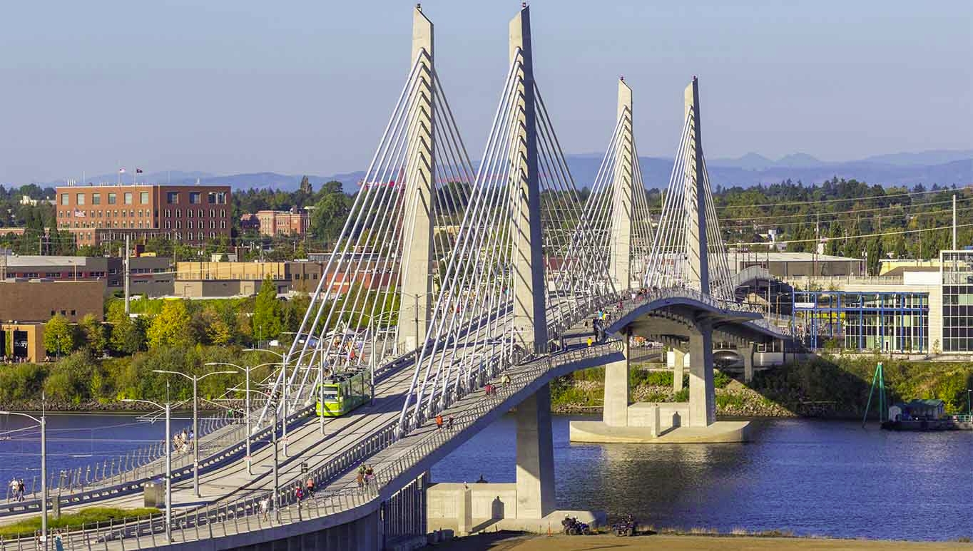
Portland’s Tilikum Crossing is an example we’ve highlighted before, of a bridge built to provide the missing modes of public transport and walking and biking. It’s also really nice to look at, and an interesting, attractive and accessible feature of the city for locals and visitors alike.
This option is something we’ve highlighted numerous times before. It’s extremely frustrating that in 2021 – when the previous government was looking at a ~$700 million pedestrian-bridge for people walking and cycling – Waka Kotahi said it would only cost around an additional $1 billion to have included public transport in the design. At the time they didn’t recommend that particular option, because they claim they were only asked for an active mode bridge. I suspect there was also an element of not wanting to propose something that would solve the problem but that would hinder them from building more road lanes.
There is, however, potentially a case for some additional road capacity.
This data comes from Waka Kotahi, and shows the average weekday traffic volumes across the bridge by direction. As you’d expect, there is more traffic travelling to the city in the morning, and more travelling away from the city in the evening.
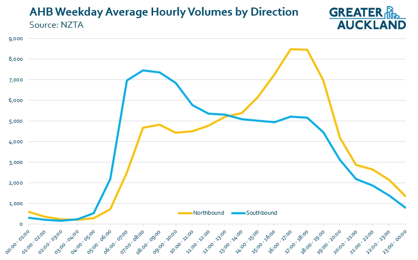
However, in practice the configuration of the bridge is also changed so the peak direction gets five lanes while the counter-peak direction has just three. This results in the counter-peak direction moving more vehicles ‘per-lane’ – or to put it another way, perhaps counter-intuitively the counter-peak direction is busier than the peak direction. Potentially including a couple more road lanes in a new crossing, so both directions always have the same number of lanes available, thus removing the need for the barrier machine, is something that might make some sense.

For those worried about the lifespan of the clip-ons, a new bridge that adds the missing modes plus those lanes mentioned above, in combination with road-pricing, could be enough to reduce demand on the existing bridge by enough that it would allow you to remove the clip-ons and replace them with new ones. And all of that is still going to be way cheaper than just a pair of road tunnels.
Timing
If a new road crossing was to be built, the key question of when it is needed is perhaps even harder to answer.
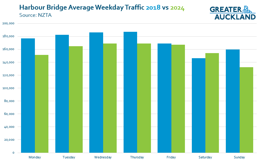
Traffic grew fairly consistently over the Harbour Bridge from its opening in 1959 all the way through to 2006. However, since then, things have been less predictable. When the busway opened, it became a massive instant success – meaning at peak times, 30-40% of all people crossing the bridge are doing so on a bus. The Global Financial Crisis also likely had an impact, but traffic continued to rise before plateauing at around 171,000 per day before COVID struck. After which, all bets are off: even this year so far, figures are hovering at less than 160,000 per day.

It’s also interesting to compare the actual traffic volumes to what was predicted in the 2010 business case, which had assumed growth would continue and that a new crossing would be needed in just a few years:

One of the things driving the change in trends at the moment has been the rise of working from home, with noticeable drops in volumes on Mondays through to Thursdays.
This does highlight that predicting when we’ll need something is incredibly hard, as there are many unexpected or unpredictable developments that can have significant impacts on the future demand.
So to that end, we should focus our immediate attention and resources on the things we already know we need, and which are demonstrably needed right now – the missing modes – and then see if we still need something else.
Hey there – if you enjoyed this post, especially if you regularly rely on Matt’s dogged data-vis to dig out the angles other media misses, you might like to support our work with a donation or a recurring subscription. Thanks to all our readers and subscribers for making posts like this possible!

 Processing...
Just crossed the bridge this morning, on a bus at ‘peak’ time (8am), crusied across at 80kmh all the way. I still don’t know what problem we are trying to fix and Wayne Brown, Labour or this Coalition haven’t been able to explain it.
Congestion? The bridge isn’t congested
Resiliancy? I imagine the availablity of the bridge is at about 99.99%. There is also another crossing on Upper Harbour
Public Transport? It’s been clear the tunnels would be for cars first pushing PT over the harbour into the late 2030’s
Once again, 6 years of wasted Labour Government, could have had Light Rail as our mode of choice and instead of a ridiculous bike bridge just spent a couple of billion more and done a PT and Active Mode bridge.
Reality is, nothing has been built and lots of things proposed because its simply not needed and all political parties know it. It makes you look like your are serious about infrastrcuture by proposing things you’re never going to be around to deliver.
Ask any driver trying to get across the bridge and they will tell you the same thing, queues to get onto the motorway. Continual Buslanes everywhere we can roll them out would be a game changer and at little cost.
I cross the bridge on the NX1 before 7am, never a problem. The southbound busway joins general traffic after all the other merges, so the traffic is generally flowing well.
Coming home is a different story. The buses get stuck in general traffic, however the cause of that traffic jam isn’t the bridge – it’s the motorway further north.
What’s needed is a dedicated bus lane from Fanshawe northbound over the bridge to join up with the existing bus shoulder lane.
Yeah it’s ridiculous. A busway/bus lane is needed right through the CBD – Customs, Fanshawe – proper bus priority, etc – stop cars turning out of car parks like at Bradnor lane holding up full buses. That BP on Fanshawe should be closed. Not to mention the idiotic planning with cars always turning in front of buses to turn left at Victoria park – the same idiotic planning happens in the morning by the Fonterra building – single cars holding up multiple full double decker buses. Ban the left turns.
It can take 15 mins just to get to the on ramp – and then deal with Curran st, etc.
The Curran St onramp onto the bridge is also a choke point, can attest from catching the 866 in afternoon rush a few times, but that’s a merging problem as it clears up once you get to the top of the bridge. People just crawl through the onramp traffic lights regardless of the colour.
I used to catch the 866, but quickly realised it was quicker to get the train into the city then the NX1 (or 70/NX2 if the trains are broken).
As for the onramp congestion lights, it’s my understanding that “one vehicle per green light” means you can go through on red if no other car has gone through before you on that green.
“it’s my understanding that “one vehicle per green light” means you can go through on red if no other car has gone through before you on that green.”
Interesting interpretation. Any support for that? I don’t think traffic court would be impressed 😉
Well when the politicians try to force everyone back into the city again, you’ll see the rise in traffic back to that of the beautifully heavy 2010’s
The Auckland Harbour Bridge Authority commissioned a report by the original bridge designers Freeman Fox into a potential crossing via Meola Reef. Their report in August 1974 included borehole data from Tonkin and Taylor confirming that the hard basalt of the reef was sitting on soft sediments so their proposed structure would require deep piles anchored into the bedrock beneath – although it reckoned that the reef would provide some lateral support to improve earthquake performance. The critical thing is that a whole new motorway route would be required, partly through Point Chevalier but mainly via Birkenhead and Glenfield.
Ahhh thanks for that insight.
I’m sure the inhabitants of Birkenhead and Glenfield, myself included, would be delighted at the prospect of a new northern motorway connection. I cannot see any realistic pathway for a motorway sized road through those suburbs that will not require bulldozing dozens if not hundreds of houses and the consequent displacement of thousands of residents. To say nothing of the irreparable loss of yet more native bush reserves.
Wouldnt the rest of the harbour be on the same soft sediments?. So not better but not worse. The fact that no boats pass through there means there is no requirement to build the bridge to any height. Causeways can make this much cheaper.
Still lools like a good idea to me. Although it shouod be rail/light tail/bus/walking/cycling only.
I think the parks on both sides are a bonus. The meola reef bridge should be a green bridge where the western springs park continues all the way over the top deck to the kauri point park on the other side. A continuous park from one side of the harbour to the other. With walking cycling on The top deck and maybe light rail/bus underneath. Leave cars out of it.
Boats do pass through there – to Westpark marina and there are yacht builders in Hobsonville Point too. The bridge wouldnt need to have as much clearance as the harbour bridge but couldnt just be a full causeway like the NW motorway at Sulphur point. Though the hills on the north side of the harbour would necessitate a high span (like the upper harbour bridge) unless it would go straight into a tunnel through Kauri Pt.
I meant the reef only. Of course the northern part has boats through. My point was the span would not have to be as wide as it first seems
The Mayor offered a proposal and said there maybe other better options. The Herald published a proposal a few days later showing a bridge 500m west of the existing. It needs more thinking.
SH18 causeway across the mudflats has arguably worse ground conditions than the reef. If a 43m clearance bridge is built over the channel, it’ll already be half way up the hill at landfall. It’d be similar to the upper harbour bridge. If it was just a lane each way like the original Upper harbour bridge it could connect Motions Rd to Onetaunga Rd.
I want to see the introduction of travel demand management first thou, which should defer any need for another bridge for a long time
I think we should hold off building a new harbour crossing for now as many improvements are being made to our infrastructure that will reduce congestion. Spending several $billion on a harbour crossing that might have a low benefit to cost ratio should be put on hold.
The new CRL is going to double the number of passengers and take many cars off the road.
AT is introducing a time of use charge that will cut the numbers using the motorway.
Our bikeways are being connecting and bike numbers are up as Shaun Baker wrote on GA 18 July. I would add to his list the new 7km Whau bikeway which is due to open mid next year and will be popular.
AT have made good alterations to several bus routes including the Outer route and introduced several more frequent routes an winning customers.’
There are some dynamic lanes which are reducing congestion.
More people are living close to bus and train stations and many more apartments are coming to Pt Chevalier, Panmure, Henderson, Mt Eden, etc.
AT should be going ahead with a new bus station at Rosedale next year that will attract more customers.
The $50 weekly fare cap will be an offer that some will find hard to refuse.
I like the last graph title being its legend – nice.
Exactly. When traffic counts over the bridge have barely changed in twenty years, just what problem are we trying to solve? If hard-headed business analysis was applied to the “problem” you would conclude that if investment in growth was to occur, it would be worth putting it into an option which has experienced significant growth over the last twenty years – public transport. And if road pricing (didn’t we use to call that “tolling”?) was imposed – which the present government and the mayor seem to favour – then the “problem” might go away of its own accord.
Surely this option would appeal to a government which is ideologically driven by “value for money” and opposing “white elephant” infrastructure projects?
But it seems that they are more driven by inconsistency and hypocrisy than by any loftier principles. I just hope that they are as good on the delivery front as Labour was and that we don’t end up with something we don’t need and which will make our city even more congested.
If hard-headed business analysis was applied to the “problem”, other parts of the region like the South might be higher investment priorities than a *third* way to get to the North.
Like a Southwest RT line perhaps? Ooops! That might end up looking like something Labour proposed!
The government, and many of it’s MPs are acutely aware of their sponsors, donations and therefore their interests.
Interests very much aligned with enlarging motoried road transport facilitation, and excluding any mode shifting initiatives.
Politics, posing as economics, once again and stuff the environment.
Yep, just now according to RNZ they want to increase the number of public servants commuting to the office to…. wait for it… increase parking revenue.
It is just sad.
Making all public servants do all their work from home will certainly increase the spend on motoring and increase peak time congestion, and therefore more demands for more roads.
And it may well increase CBD spending.
But it will not increase total spending.
It will just relocate spending away from somewhere else , and exacerbate economic stresses elsewhere in the economy. Out into the burbs.
Commute time is largely wasted time. Eliminating some two way commutes totally, just one or two a week, would undoubtedly save more time, then raising urban speed limits can ever achieve.
And at the same time reduce exposure to expensive road accidents.
Reducing waste, including wasted time, is economic enhancement
One could also see it as an additional aid for foreign petrol companies like BP, given the share of ICE cars and people commuting to work by car. Not sure if that makes sense in ECONOMICS 101.
There are one possibly two problems to solve.
One is the lack of a PT and active modes crossing, the other is the longevity of the clip ons.
The actual problem to be solved is 3 things:
Resiliency, clip on replacement, and PT/active modes.
Congestion etc is just a bright sparkly thing for them.
Weather is getting worse and recent accidents have highlighted the vulnerability of the AHB (and knock on effects to the rest of the city).
The clipons do need to be replaced – and closing them to replace them would cause too much disruption so an alternative is needed.
A PT and active mode option is also long overdue.
The proposal for the curved bridge adjacent to the AHB has merit.
If it had 2 PT lanes, Active lane and 5 general traffic lanes then you could replace the clip ons one by one (possibly with smaller but stronger ones).
I don’t agree with making each bridge a one way only bridge as that reduces resiliency.
Once the clip one are replaced you would end up with a total of 11 general lanes, 2-4 PT lanes, 1-3 Active lanes depending on configuration.
All for less than $4B.
Additionally as the designer mentioned, the new bridge (and I believe the upgraded AHB) could both be fitted for screens that would reduce wind age by half meaning closures would likely only be during a direct hit by a cyclone rather than the current roughly monthly closures.
Just build a replacement bridge. A double-decker, going north, 1 Metro train line, 1 bus lane, 1 cycleway, 1 walkway, and 5 lanes for cars, Double up for south, maybe add some redundancy for another metro or light rail line.
We are still intent on building the wrong thing first.
We are counting car movements, as a proxy for people movements.
Providing a spacially more efficient way of moving a significant proportion of the people. and the cost savings in construction, operation, and ancillary provision such as journey end car parking will be immense.
Tunnelled, (or bridged) light rail under the harbour and a mix of on and off road, surface, tunnelled, and perhaps elevated at each end has the potential to add considerable extra people carrying capacity across the harbour choke point at much lower costs then expanding road capacity wherever it is located.
We just need to look at Sydney for inspiration and it’s newly opened under harbour Metro lines.
Electrified twin light rail tunnels are a modest 6.2 m diameter and have much reduced ventilation and fire suppression requirements over the comparitive twin 14m diameter Waterview tunnels. So less then 20% of the excavated volume.
But arguably have more people moving capacity.
You’re probably right, but car-heads will need to be thrown a bone in order to get a bridge crossing over the line.
100% start with small fixes, NZ is obsessed with big solutions that never happen.
To be honest I don’t see another crossing ever happening, unless they are realistic.
The meola reef idea seems like a great transit crossing idea at first but like the road crossing it seems to create more problems than it solves.
Yes it would be nice to see proper transit serving western North shore, I can imagine Birkenhead and Glenfield becoming a bit like north Sydney and crows nest with more apartments and commercial space.
But on the southern side of the harbour there already is more planned transit to the west like the north west bus line, this will make it very difficult to to build a connection between point Chevalier and the city, this will create a situation where all transit enters the city from one direction, so many expensive city loop systems will need to be built.
I personally think a lower bridge should be built slightly east or slightly west and the sugar factory and navy will need to use barges to move freight upper harbour. The new bridge could still have some car lanes on it, so the clip-on lanes could be removed.
In reality this will never happen, not in the next 30 to 50 years anyway, so most of us will be lucky to see it completed in our lifetime.
Another road crossing is simply not needed now or in the future. I’m sure by then we will all be more educated on the benefits of using public transport & active modes considering a more dense living situation and climate change. The rest of the roading network simply doesn’t have the capacity to handle another crossing, and shouldn’t be changed so that it does.
Time of use charging and a decent PT crossing will solve all this.
I think it should be a metro or light rail line landing at about sulphur beach & continue in parallel to the motorway or in place of the northern busway. We want fast, straight, direct as can be.
Not much, it seems, has been talked about the city end of the route for lightrail/metro, but I think it would probably be best to land about at the ned of Jellicoe St where the remaining two big silos are. High enough to clear big water craft and so probably elevated a bit on land until Daldy St (station about here – new Wynyard Pt development) then onto Fanshawe St. Alternatively, more direct, keep it elevated and go down Madden St across the Viaduct Basin (high enough for small yachts?), along Custom St W, lower to ground level about where the Downtown Carpark (soon to be new development without the flyover). Station here. Up Queen St, station about Queens Arcade. Carry on up Queens St…Dominion Rd…
If they had got onto this quicker, it could be better to put the line through Wynyard Point itself while they develop that (Te Ara Tukutuku), slightly closer to Northcote Point, but not by much as it’s angled eastward so much.
I think a small bridge linking Beach Haven with the Upper Harbour Highway could be of value.
All the current traffic and PT from Glenfield south heading east before joining the gridlock leading up to the bridge could instead go west to UHH and then onto the NW Motorway. Buses would get access to the NW Busway and the cyclists to NW cycleway. Could be buses to the western line as well.
Nice at first glance, but it would suck traffic off Glenfield Road into Beach Haven, for little benefit and huge cost. It was thought of long ago and dropped. We have a very nice ferry to Hobsonville Point instead.
So commuters from that lower south east of the north shore go to Beach haven, to get a ferry to Hobsonville Pt, to get on a bus to get onto the UHH? Or just continue to jump in the car and clog Glenfield Rd?
Taking traffic off Glenfield Road is the point. But if we think we can get it through (and we won’t) make it a PT and active bridge only.
sorry, lower South West
Would possibly be the only feasible location for a commuter gondola in all of NZ, especially if a proper RTN busway was installed along the Upper Harbour
I agree. Combine that with the mayors meola reef bridge and light rail through beach haven and you get a solution to the second harbour crossing and the north west rapid transit problem in one. And more effevtive as its spreads the traffic rather than shuttling it through the same narrow corridors all the time.
Has anybody seen any data on what changes to the ferry service have meant for bridge traffic? I can still remember when the Birkenhead ferry service would whisk many hundreds across the harbour in peak hours. I’ve recently used it a few times and the numbers are a fraction of what they were.
The trouble with the ferries is that the wharves are at sea level. On North Shore, most of the main roads and bus services run on ridge roads, so it’s quicker to stay on the bus to the city. The ferries work well for people who live too far from bus services to leave their cars at home, or who can reach the wharves without catching an FTN bus.
That limits the passenger catchment that they need to serve. Other ferries don’t have faster bus connections to the city.
Agreed, Birkenhead, Northcote will never be very busy unless you line Hinemoa and Queen st with apartments which will never happen.
It did used to be much busier before COVID, but I suspect with WFH and all the crap with changing times/frequencies people have been put off. A shame because it is a great way to get to work.
Maybe the terrain issues are dealt with by gondolas. The private operators seem to be back in the news again and look keen to start in Queenstown.
In all seriousness, if they can make it happen and build the infrastructure across the harbour into Birkenhead and north, and wherever south we think a route would be worthy, let them have it. have dedicated bike ones every, say, 3 carriages.
An excellent point.
Back before the T3 lane when bus times were far longer the ferry had a slight time advantage, but no longer.
On the other hand, I find the ferry trip better for my mental health, in those days I would arrive at work in a much better frame of mind than if I had taken the bus.
I was expecting a post on this mayor bridge idea sometime.
Yes, agree need a PT/active mode bridge and later replacing the clip-ons is the way to go.
Actually I miss read/heard the post earlier thinking you meant build an extra lane each on the new replacement clip-ons. If that was possible maybe this is a good idea.
Building 3-lane clip-ons would be the exact definition of “doing the wrong thing better”. We don’t need more car lanes. If the clip-ons ever have to be replaced, they should be replaced with a bus lane each way, and walk and cycleways.
Maybe a truck lane too, if the govt at the time are feeling minded to actually help (some) of the economy rather than just pandering to the petrolheads with “trucks need roads too” projects!
The post mentions putting a lane each way on the new PT/active mode bridge, so was suggesting instead of doing those extra lanes on that, make a 3 lane clip-on.
I love the idea of spending 2 hours commuting to work “to increase productivity”
if you add in ” of carparking ” the sentence makes more sense.
Any road pricing should include a discount (or even be free) for T2 vehicles, although would require fairly sophisticated cameras to detect stuffed dummies in the passenger seat. This would encourage car-sharing where possible.
It’s a concept that doesn’t work in practice, and not just because of the dummy passengers. Measures to encourage car pooling don’t provide the independent, sustainable transport options that people need.
As I may have previously mentioned, the problem with our city is not the lack of another harbour crossing, it is all the useless private motor vehicles that occupy our stunning piece of infrastructure popularly known as the Auckland Harbour Bridge.
Our mayor may be a reasonable representative of the city, but he is a child of mid last century. His proposals smell like engineering solutions; when we need thoughtful proposals to reduce climate change impact, as Wellington takes us backwards for a few years.
The wheel was the worst invention of human history, and although it cannot be un-invented, it is useful to consider how a city might be, without these odd shaped devices.
For a start, apartment living might be a little more logical, traffic would be without wheels so somewhat less stressful, and perhaps some of the post code lottery could also be addressed.
bah humbug
“The wheel was the worst invention in human history” – this guys too backwards even for the Amish
“our stunning piece of infrastructure popularly known as the Auckland Harbour Bridge.”
Sorry but the current AHB ain’t that stunning. I’ve always felt like I was taking crazy pills with all these other billion dollar solutions instead of just demolishing the thing and building a better one to replace it that includes space for transit and active modes on their own. A nice cable-stayed bridge would look better than the ugly 1950s truss anyway.
Yeah I think it’s more the general surroundings that make “it” look stunning.
Mayor Brown has the ability to cut through the BS and see when something is completely unrealistic and why, ie 10 yrs spending of all nz roading projects. We need more people like this in positions of power rather than complete fools who get led along by consultants who are actually incredible talented in their particular field but fail to see the bigger picture of how a country of 5M will ever pay for their grandiose ideas.
and yet Wayne proposes a destructive and frankly unnecessary boondoggle of his own.
Get rid of the consultants and politicians, sure – put the experts in direct charge of these decisions, not populist numpties.
“We need more people like this in positions of power rather than complete fools who get led along by consultants who are actually incredible talented in their particular field but fail to see the bigger picture of how a country of 5M will ever pay for their grandiose ideas.”
Yeah. How about those RoNS….
‘But-but-but motorways good!11!! Only public transport bad and grandiose and unrealistic!1!!11’
Problem is he’s a lot better at calling things out than actually delivering anything. I’m not sure more Wayne Brown’s around the country would be that useful.
And in todays news , Viv Beck CEO of Auckland’s Heart of the City, is bemoaning, that 30,000 people a day have forsaken both an unproductive commute, and a major contribution to city congestion and emissions, in favour of spending of just some of their productive working time at home to work on some tasks, without office distractions.
https://www.nzherald.co.nz/nz/heart-of-the-citys-viv-beck-urges-auckland-council-to-lead-in-tightening-working-from-home-rules/5QDZTCMUFVCFJG5KQHSRBOVVSU/
Surely abandoning unproductive commuting time, and releasing peak time incredibly constrained transport capacity is a massive low cost gain in economic efficiency?
Or is preserving existing and previous business status quos, ahead of furthering dynamic economic efficiencies, the prime objectives of our conservative business promotion political operatives?
The CBD of Auckland enjoys a huge locational advantage and can evolve even faster if outdated business priorities, such as council subsidied parking, and central government subsidised roading provision loose their privileged provision.
“Surely abandoning unproductive commuting time, and releasing peak time incredibly constrained transport capacity is a massive low cost gain in economic efficiency?”
If the job can be done from home, it can probably be done from [insert low-cost country here]
Be careful what you ask for.
Hypothetically speaking it is possible for a bridge to be built there, why is there an assumption that it would be built as a motorway? Why not a typical local bridge with bus lanes and active mode options?
I certainly could have done at least 20% of my job and at times 40% of my job better at home free of distractions.
But I also needed to spend at least 40% of my time overall being able to interact freely with collegues, developing joint objectives, problem solving, and solution implimentation. The required on site supervision, of up to 50% of my time, was independant of office location, but could not be accomplished from offshore.
But one less commute a week would have reduced peak hour congestion and gifted me at least 1 1/2 hours a week to do something more productive, reduced my emissions, and extended the life of my car.
It would have also reduced my exposure, to probably the most hazardous activity in the week.
Why do people think working from home, or not, is a binary choice?
For many it is best not. Efficiencies can be gained by a period of working undistracted from home.
It should only be the proportion that is debatable.
A family member is a Public Servant in Wellington, reporting to.a manager in a provincial city. So contact between them is very largely irrelevant as to whether they either of them are in their offices or not.
For much of the last 8 years, since the Kaikoura earthquake the Department/Ministry, he works for has actually not had sufficient accomodation in Wellington for it’s entire staff because of seismic building actual damage, or unacceptable risk.
I think at one stage they were down to between 1/2 and 2/3 of functional office space for their Wellington staff, but their essential.work continued with suprisingly little degradation.
This was all well before Covid.
So if it was good enough for staff then to help the government out by accepting alternative working arrangements, one has to question government motives for now reducing flexibility and resiliance, and increasing tenancy costs now.
Exactly this, even with stuides you still can point to whether a certain individual is more productive at home, in the office or both. Back in the good old days, managers had people report to them and you were measured on whether you were doing your job or not. Now Mr Ceo of New Zealand thinks despite being in a coalition of ‘less Government’ they can nanny state things and tell people whats best for them. All so that a cafe can sell some scones and flatties.
How about build lots of central housing to allow those businesses to thrive 24×7, how about the uptick in local suburban hospitality thats been thriving outside of weekend hours.
What a populist..and I can’t even call it that as I don’t think they have the backing of the general public on this, nonsense. Send an email to the public servants, don’t really need a cabinet press conference.
My comment was more for those to expect to work from home 100% of the time, or more out of the office than in.
I don’t think white collar jobs will ever need to go back to 5 days a week and I am not sure that was what the new directive is. I took it as there will still be some flexibility but the majority of a working week will be in the office, for the reasons you mention. But I would like employers to stagger this, so offices – and CBDs – are not ghost towns Monday and Friday.
On a related matter, I don’t think the 4 day work week is out of the picture yet….
There isn’t a lot of 100 % WFH in the Public Service and those that do generally have an agreement locked in so I’m not sure what is actually going to change.
National appear keen to be talking to their base at the moment, which is good as it will speed up the time until our next centre left government.
Auckland is a city that needs to reverse decades of terrible car dependent planning. More car infrastructure across the harbour of any kind is opposite to what’s required. Imagine how good it’d be if the mayor understood the Council work on reducing transport emissions.
I know that tunnels are a bad idea but I still have wistful thoughts of tunnels linking the bottom of SH 16 – the port motorway and train lines with the western edge of the Devonport peninsula and then a causeway up that edge linking back to SH 1 at Akoranga.
Here is a MAP : the circles are Round Abouts.
https://www.google.com/maps/d/u/0/edit?mid=1h82IL8rvMlXjoIoBHdC2JPyxoxsMjOE&usp=sharing
This still has a LOT of destruction of native bush, in parts of the north shore with vulnerable Kauri too. Can’t see it being less expensive than a simple public transport and active mode bridge from Wynyard Quarter to Sulphur Beach either; and I don’t understand the argument that the next crossing must be in a radically different place to offer “resilience”
What exactly is the point of this? We have a huge motorway and bridge already through the city – we don’t need more.
Imagine the destruction to those areas. And look how sparsely populated all that is.
Improve density and PT along existing lines, and use other levers for congestion charging, increase parking costs, stop sprawling, etc and you don’t need more lanes.
Just more lines (ie train + bus) – we barely have a functioning rail line (ie singular) – buses are improving but are still at a base line and our cycling network is not even close to being anything like a network.
Pump $33 billion into that and you’ll have orders of magnitude better results than a bridge across a swap and forest plus motorway to Whangarei
That route appears to take out most of Birkenhead town centre.
thats a tunnel under the town which is built on a ridge
One argument could be to stop pushing motorway traffic through the beautiful Takapuna, Hern Bay, Downtown, Auckland and so much prime land and push it to the Water view tunnel which is over specked and under used.
The Existing Bridge and downtown Motorways could start to be pulled back to 3 lane , bus and bike lanes and re develop the beautiful area near sulpher beach and so much potential.
John Tamahere’s proposal from his mayoral run to build a replacement harbour bridge and slide it onto the existing piers may have been very optimistic in technical feasibility, but i can understand the compelling fantasy of just being able to… replace the AHB and correct its mistakes. 10 lanes, walking and cycling paths on both sides, a busway that could be converted to light rail. If only.
Yeah. Except that ten lanes wouldn’t be correcting a mistake. It would be exacerbating one.
In my opinion building a bridge to the western North Shore is a much better idea than previous ones. The worst thing would be losing this opportunity to finally have good connections there and connecting same spots in the north and south like some people would like. It’s like building Light Rail route along Heavy Rail route.
Ideally the existing bridge should be remodelled to cater more for Light Rail and active modes. The other crossing (which should be a tunnel) could be made for cars and heavy rail.
Bridge from Kauri point to Pt Chev
was thrashed out back in 1998 with the outcome Not viable due to the large negative impact on the Point Chevalier community plus the eco system of Meola reef and historical Kauri Point. “Resets harbour crossings with two bridges proposal is a much better alternative” – connecting more of Auckland to the main trunks.