This is a guest post by Shaun Baker on the importance of filling the gaps in our cycling networks. It originally appeared on his blog Multimodal Adventures, and is re-posted here with kind permission.
In our towns and cities in Aotearoa New Zealand, there are areas in our cycling networks that have little to no cycling infrastructure installed between existing separated cycle routes. This results in a disconnection in our cycling networks, between suburbs, employment centres and public transport hubs and the safe infrastructure people need to get there. As a result, cycling in these areas can be unattractive, due to safety concerns.
These gaps can range from big to small – but if they were filled in, this would significantly improve the cycling environment in our city and improve connectivity to the wider cycleway networks.
The Network Effect
As our cycleway networks become more connected, we see an increase in our cycling numbers. This is known as the “network effect”. An example of this is the Northwestern Path in Tāmaki Makaurau Auckland, where annual cycling numbers have increased from 146,000 in 2013 to 322,000 cyclists in 2023.
This increase came as connections into the city centre, such as the Nelson St cycleway, the Lightpath and Grafton Gully were built in the late 2010s, forming the city centre bike loop which connects to the Northwestern Path to the west and Tāmaki Dr cycleway to the east. The growth can also be attributed to the completion of paths that connect onto the Northwestern Path (Eg: The Waterview Path which connects onto the New Lynn to Avondale Path and Southwestern Path).
Related Greater Auckland story from February 2021: Double Is Nothing, featuring this animation by Matt Lowrie which shows how ridership leaps every time a new link is added to the Northwestern Cycleway.
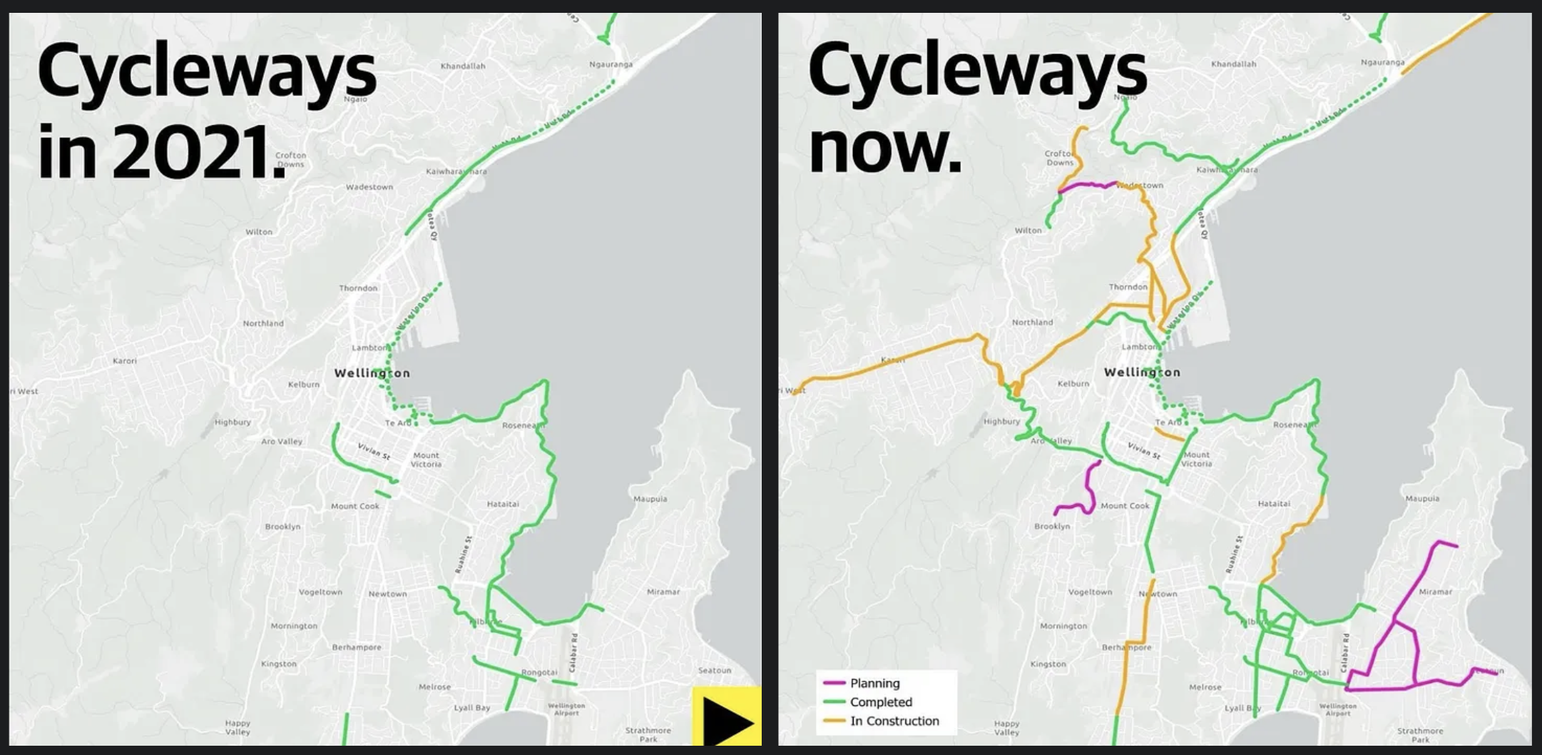
Another example of the network effects around Aotearoa is the Newtown to City cycleway in Te Whanganui-a-Tara Wellington, which resulted in cycling numbers increasing by 140% since 2022 as more cycling connections have been delivered around the city. We’ve also seen the network effect in Ōtautahi Christchurch, with the delivery of the Major Cycle Routes (MCRs). Since 2017, cycling numbers have increased by 40% with several of the MCRs either fully or partly completed.
Current and recent gap-filling projects in Auckland
In Tāmaki Makaurau, there are projects recently completed and proposed to be under construction later this year that will fill in gaps in the cycleway network.
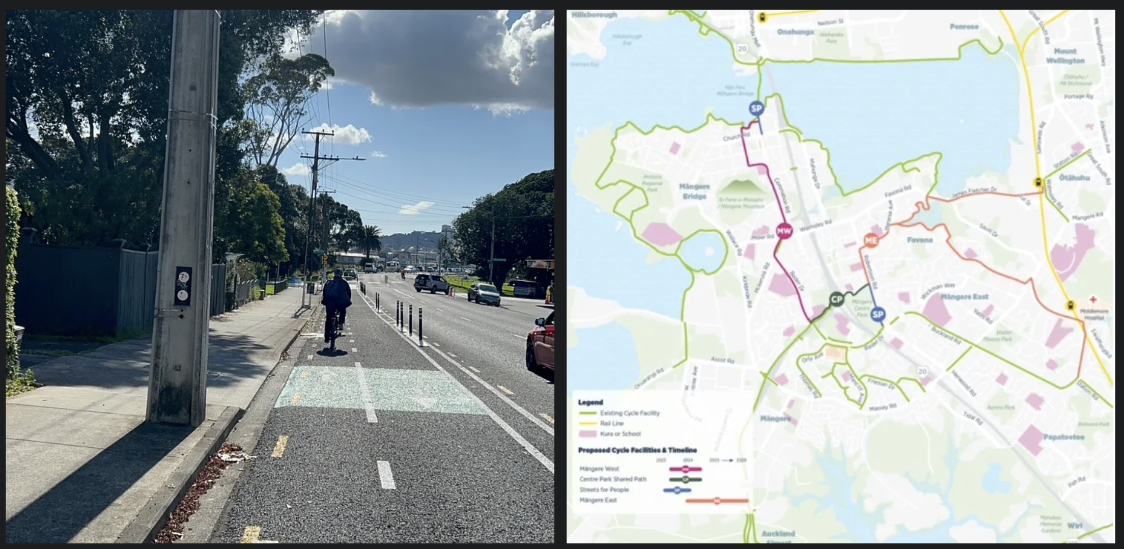
The first one is in Māngere Bridge, where a pop-up bidirectional cycleway has been installed on Coronation Rd as part of a Streets for People project by Auckland Transport and Waka Kotahi. This cycleway connects the town centre to the cycle path around Ambury Regional Park and to Ngā Hau Māngere, which opened in 2022. This in turn goes over the water to Onehunga, and connects to the wider cycleway network with the Southwestern Path towards Mt Roskill and Mt Albert and the Waikaraka Cycleway towards Sylvia Park.
There are proposals to join up the existing cycleways in the town centre to Ngā Hau Māngere and train stations in Ōtāhuhu and Middlemore, via the Māngere West and East Cycleways – with the Māngere West project set to begin construction this year.
However, the future of these projects seems uncertain, due to the ending of the Regional Fuel Tax and a reduction in funding allocated from the National Land Transport Fund for walking and cycling projects as proposed in the Draft Government Policy Statement of Land Transport 2024-2034 (GPS).
The Māngere West cycleway has been identified as a key project in the Draft Regional Land Transport Plan 2024 – 2034 (RLTP), which was recently out for public consultation.
We go west to Hendry Ave, where upgrades were completed last year as part of the Transport Choices package to improve safety for cyclists. Traffic calming was added by installing speed bumps with bypasses for cyclists, raised crossings, and lower speed limits. This upgrade fills a gap in the Southwestern Path between Mt Roskill and Onehunga.

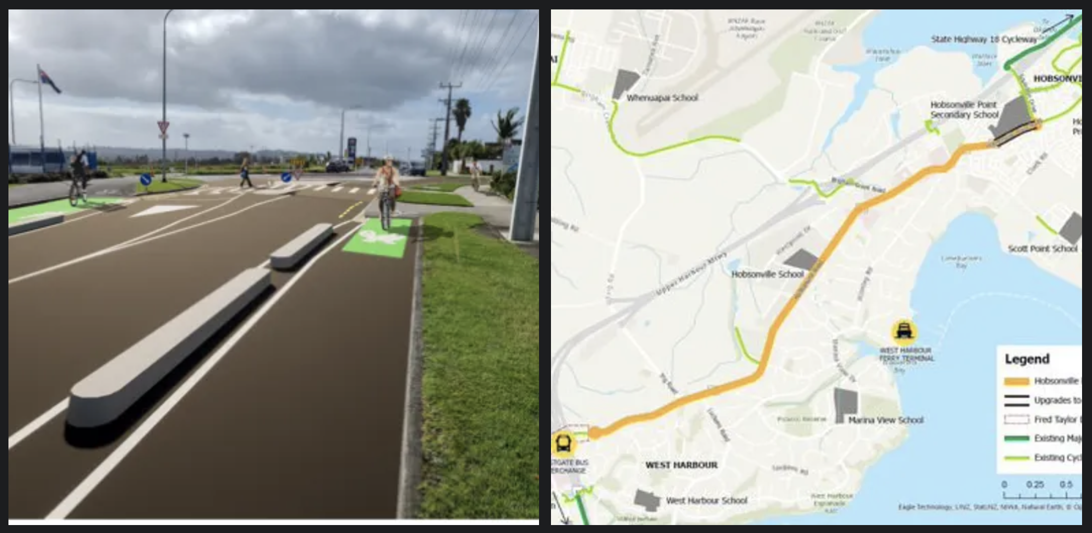
We head to the northwest and the proposed cycleway on Hobsonville Rd, which is expected to begin in late 2024. This cycleway will create a cycling connection from Hobsonville Point, West Harbour to Westgate with schools, supermarkets and other amenities along the corridor.
It will connect into the Upper Harbour Cycleway, shared paths and cycleways built as part of large-scale developments in Hobsonville Point and Scott Point, and the Northwestern Path at Westgate – and will unlock more multimodal trips, by enabling people to bike to catch the WX1 bus at Westgate and ferries at West Harbour and Hobsonville Point.
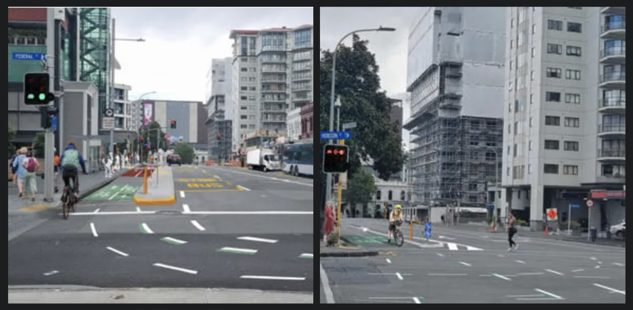
Back in the central city, a gap currently being filled through the use of tactical urbanism is Victoria St between Federal and Nelson St. This bi-directional cycleway will act as an interim solution until a permanent solution is installed as part of Te Hā Noa.
This will fill the gap between the existing cycleway on Victoria St (from Beaumont St to Nelson St) and the cycleway currently under construction as part of Te Hā Noa (between Federal St and Kitchener St), creating a full east-west link across the city centre from Victoria Park to Albert Park. This will also link in to Nelson St, Waihorotiu Path on Queen St, and Franklin Rd up towards Ponsonby Road, enhancing city-centre access for a whole lot of trips by people on bikes and other micromobility.
It’s good to see these additions to the cycleway network in Tāmaki Makaurau. And there are still other gaps throughout the city that need to be filled, to continue unlocking more of the network effect.
Major future opportunities to fill gaps on the map
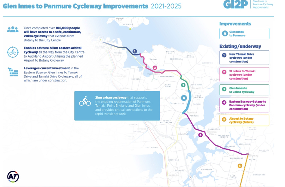
Glen Innes to Panmure Station
The first gap I’ll be discussing is between Glen Innes Station and Panmure Station. Filling this gap by putting infrastructure on either Merrin or Pilkington Rd can unlock the network effect for East Auckland by connecting Te Ara ki Uta ki Tai at Glen Innes, and the cycleways currently partly completed and under construction from Panmure Station to Botany as part of the Eastern Busway.
Prioritising the delivery of this cycling link was mentioned in 2021 when funding from the former Northern Pathway project was reallocated to Eastern Busway.
Connecting these two cycleways will result in a safe, separated cycle route from Botany to the city centre. This also will unlock multimodal trips to Glen Innes and Panmure Station, supporting homes being built in Stonefields, and at Glen Innes and Panmure as part of the Tāmaki Regeneration project.
Albany Highway between Upper Harbour Dr and SH18 Shared Path
This small gap in Albany Highway needs addressing to improve safety for people on bikes, as the cycling environment feels unsafe due to the high traffic volumes, especially when crossing the road to get into Upper Harbour Dr in order to head towards Greenhithe. [Ed: check out Matt’s video of this horrorshow intersection.]
Existing cycling protection is poor here, with only narrow painted cycle lanes around the SH18 exits. And yet this part of the Albany Highway is on a major cycle route from West Auckland to North Shore, connecting Hobsonville Point, Greenhithe, Rosedale, Constellation Station and Albany. [Ed: the missing gap with no footpath or cycleway is both sides of the Upper Harbour Drive highway, not just down to motorway – this needs solving to connect up Albany Highway North section with Glenfield Rd]

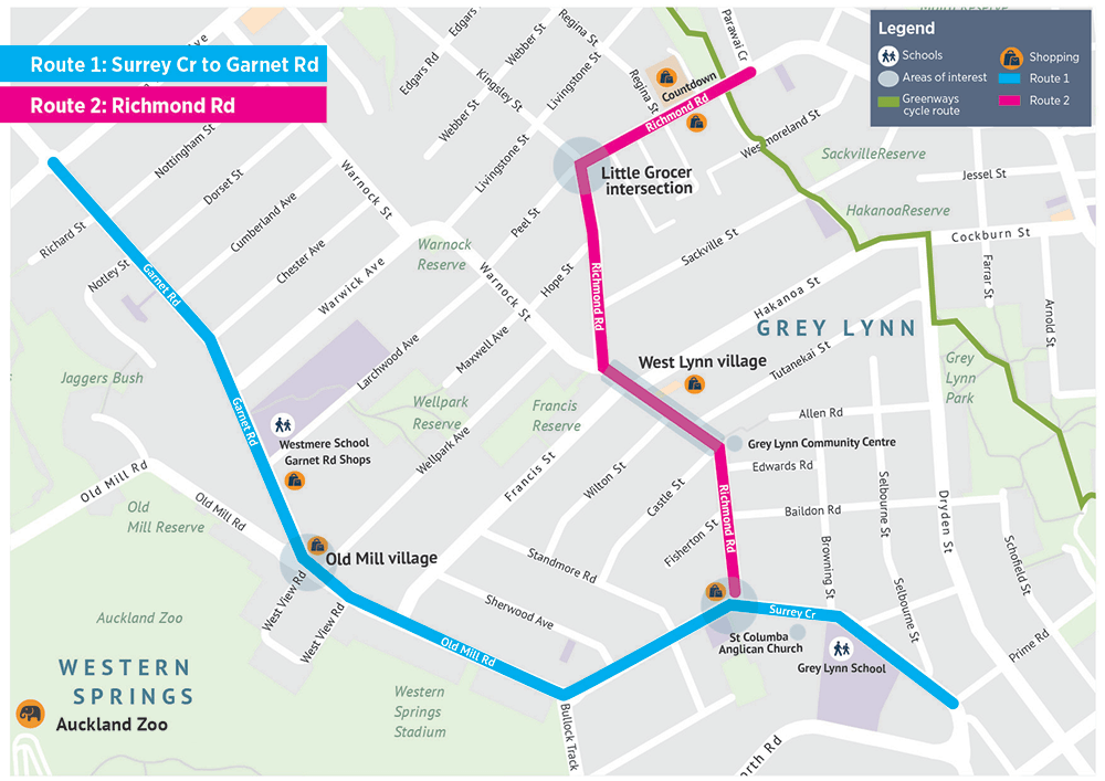
Grey Lynn to Westmere (the Waitematā Safe Routes)
Delivering the Waitematā Safe Routes will fill a glaring gap that will be evident when two adjacent cycleway projects are completed: the Point Chevalier and Meola Rd as part of Point Chevalier to Westmere Improvements currently under construction, and Great North Road (GNR) which will get under way in October.
Connecting these two cycleways to each other, and to the existing greenways that go through Grey Lynn, will enable safer journeys to local schools, shops and the attractions of Western Springs.
Not only will this create a fully connected cycle network in the inner west, it will also hooks into the wider cycleway network at each end. GNR connects directly into Karangahape Road and The Lightpath, to create a safe cycling route to the city centre, which also gives access to Tamaki Drive and the eastern pathways.
Meanwhile, the cycleway on Point Chevalier Rd will link to the planned cycleways on Carrington Rd as part of the Carrington Rd improvements, as well as to the Northwestern Path, Waterview Path, and the Avondale to New Lynn Path – thus enabling uninterrupted safe rides to West Auckland, Mt Albert, Mt Roskill, and Onehunga (and Māngere and beyond), as well as into the central city.
The gap-filling project was put on hold in early 2023 due to budget constraints, while the two Inner West projects it holds hands with have moved ahead. Auckland Transport has identified Waitematā Safe Routes as a key project in the Draft Regional Land Transport Plan 2024 – 2034, so there’s hope yet.
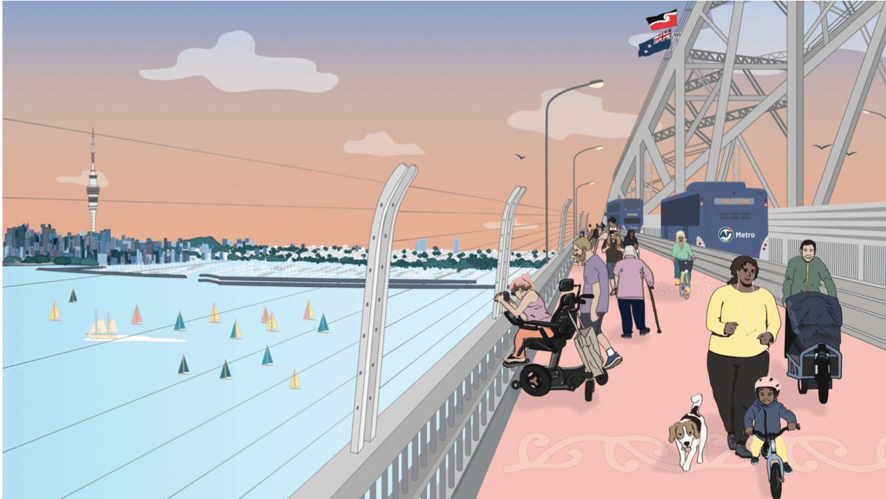
Auckland Harbour Bridge
The most notable gap in the cycling network in Tāmaki Makaurau is between the city centre and the North Shore. Having the ability to bike over Te Waitematā on the Harbour Bridge will unlock more transport choices for those to live on the North Shore, with connections to existing infrastructure like the Northcote Safe Routes, which will support growth with new homes built in the Northcote Development.
There is also potential to see the Northern Pathway extended to Akoranga alongside the Northern Motorway corridor. With the city-side cycling connections into the city centre from Westhaven, this will create a safe separated route from the city centre to Albany with connections to the SH18 shared path to Rosedale.
In conclusion, if we want to unlock the full potential of cycling to incentivise mode shift, reduce our emissions and vehicle kilometres travelled, we need to create a fully connected network in our towns and cities. Having a fully connected cycle network creates safer streets for our kids to travel to and from school, to travel to work and major amenities, and for the first and last leg of people’s journey to public transport stations to enjoy multimodal journeys. Ultimately, this will enable a safer, accessible and sustainable transport network.
You can follow more of Shaun Baker’s Multimodal Adventures here.

 Processing...
It will be up to local authorities to keep pushing ahead with safe cycling infrastructure. It is not going to be helped by central government. If you word search the just released second Emission Reduction Plan you will not find any mention of bicycles, cycles or cycleways.
Well, yes, you can’t do industrial forestry on a bicycle, can you? Sigh.
Agree. But you can do small scale ‘forestry’ on a bicycle. Here on the Kapiti Coast in a local park we have planted over 1,000 totara this winter. Mostly taken to the planting sites by an e-mountain bike towing a trailer.
That is really cool Paulc. I’ve also seen some locals doing planting at Waterview Reserve using bikes to tow tools and seedlings.
Hi Paulc – yes, of course I was being facetious / joking about our new govts tendency to “think big” (and wrong) about climate change. I have even used a non-cargo bike to transport furniture in Auckland back when – so I wonder what I might have gotten up to if I actually had had a cargo bike in those days, lol.
We also have a local landscape gardener out West who transports gear by cargo bike ( and has worked on providing his staff with e bikes for their commute) He has fitted solar panels to roof of his electric van to charge his all electric tools.
Tamaki Drive: Now that we have lovely safe separated cycle infra from the Bridge to Ngapipi Rd, and the same through St Heliers itself, there’s clear value in joining these two up. Beautiful, flat, already popular, tourist-appealing, easy to implement (at the political cost of some very infrequently used car parks).
The expensive bits: two new bridges, have just been done, and now need this continuation to increase the value of that investment. Ngapipi, of course, is also the connection to the GI to Tāmaki shared path, so adding this link would enable a circuit with that route too, a 100% suburban option, but connected to the city with all its hotels etc.
Like the continuing Evans Bay route in Welly, clearly separating walkers/riders/drivers here is of so much value in increasing the safety, obviously, but also the appeal of our glorious harbour asset.
If you’re talking gaps the Northcote safe Routes linked is patently unsafe on the link between Lake Road and Queen Street
Kia Ora,
As a northshorean, thanks for covering the critical upper harbour gap.
A couple of other notable gaps in the area.
On both SH1 – Albany to constellation and Sh18 – Const.- Albany HW there are great cycle-ways, yet they are not connected, one has to cross multiple traffic lights on foot to have a safe passage between them both. One could have easily drop a major crossing by having a proper ramp on the south side of the SH1 – near the bus station, but only stairs. This could have been an easy win.
The second and even greater miss / gap is the continuation of the cycle-way along SH1. Currently, Albany to constellation, one needs a safe passage to Northcote (and yes in a few decades the harbour bridge), safe passage to the schools (Rangitoto, Westlakes) and offices along the way (Wairau and even more Smales farm) and Takapuna. Rush hour on East-cost road is dangerous for cyclists which is one of the reason, I don’t cycle to work.
Painted lanes don’t count as they’re not safe. It’s crazy, the lanes are there and they go past the schools but they won’t put the safety infra in.
Last weekend I took my two kids to the Library via the Māngere Bridge pop up path, and at 7.25 years and 4.75 years old respectively, they both enjoyed the independence of biking. I effectively shepherded them through the road crossings, as they are rather intense, and definitely need a grown up bike brain to negotiate, or perhaps an 8.25 year old.
This connection links the beauty of the waterfront with the spectacular infrastructure known as Ngā Hau, and creates a true oasis for bike persons.
With the Onehunga Bike Hub now in place, and a semi functioning train line, bikes can move around the isthmus rather easily.
The less central areas are still horrifically disconnected however, and these are the gaps that you mention.
If the Northwestern Path has proven such a success story, and with the excellent infrastructural work between New Lynn and Avondale; there is more than a cyclist’s fairyland…this is cost benefit health benefit, community benefit, fun benefit positive, and there is zero justification for not believing in these bike paths….unless you never learned to ride a bike…which is a suspicion I have with some of these political types who dislike bikes!
Also skateboards are cooler than bikes and we need to stop being so anti-skatey, just because they are cooler than us!
bah humbug
Albany Highway near Upper Harbour Dr intersection
This is my biggest issue for the Shore. So much good stuff going on with cycleways, then you have this small but ridiculously unsafe section.
I wrote to AT in May 2021, and followed up in 2022. Nothing has happened that I am aware of, so suspect it will take until somebody dies before anything is done.
Response back from AT in 2021 in part:
We’re currently investigating this intersection and also the lack of pedestrian amenities from Korari Way to Unsworth Drive.
While we don’t have any plans at present, we’ve taken the concerns you’ve raised on board and will forward the suggestion to consultants that have been engaged to come up with a scheme design for the project.
We don’t have any timeline for works but we anticipate we’ll have some concepts by the end of the year
I feel as though some money has been spent on consultants over the last ~ 3 years, but nothing done, not even some smaller tactical improvements.
It frustrates me so much when I see hundreds of millions of dollars spent on NCI not far way that helps speed a lane of road traffic to go north.
Trying to do too much in a project for this intersection results in no funding. It needs an option that does just enough to achieve full safety, without over-reach to upgrade all of the road up to Sunset Road. It is a difficult site, with steep, unstable slopes to the east and a reservoir tank to the west.
That intersection should be nuked from orbit. Matt’s video is from 10 years ago and nothing has been changed.
Just make it a normal T junction or a roundabout.
Now that the separated path leads to it, not having a safe crossing here is crazy and neglectful. The path would get more users too.
AT wasted a small fortune on Upper Harbour Drive putting in concrete islands, taking out the same concrete islands, and putting in rubber blocks to end up with something no better than when they started. They spent nothing fixing the actual problem which is the intersection.
I thought the bad drivers took out the concrete islands…
Other way round.
Well, if they had bolted down the islands, maybe they wouldn’t have jumped out at passing drivers, lol.
concrete drivers took out bad islands?
If the east west link happens then a path between Onehunga and Slyvia Park and Panmure would be good. Bike connections between Slyvia Park and Panmure shouldn’t be that difficult.
Watch out for Minister Scrooge taking away the harbour edge path instead of completing this link as part of EWL.
I’d prefer it had nothing to with the east-west link motorway, but agree Onehunga to Panmure is the most obvious gap to fill for me. I recently biked the loop from South western, to Panmure, GI and into the city and back via the Northwestern. It was a great weekend ride and managed to get almost the whole 46km before my ebike battery went flat with about 500m to go.. The worst part of the whole loop is biking along Mt Wellington highway, even on a weekend.
I’m a pretty confident biker and mange to bike along part of Neilson street to get to work everyday, but Mt Wellington Highway is worse than this.
Another easy win which would help me every day would be to re-instate the link between Miami parade and the Waikaraka cycleway. This would mean I would only need about 100m of Neilson street.
FYI, try riding via Musket Place and Ireland Road between Sylvia Park and Panmure if you want to avoid Mt Wellington Highway when cycling the isthmus loop.
From Sylvia Park to Otahuhu could be done by following the rail line under the motorway avoiding the tricky/constrained motorway interchange. I suspect room need to be left for a 3rd (4th?) main line though.
I started cycle commuting from Howick to CBD in 2018, and today things are meaningfully better now. Most of the gaps have been plugged, and at an hour it’s faster and much more reliable than the bus / train combo.
There are two popular routes from the east, lots of people turn right after the Panmure bridge and use the Pt England waterfront path to Taniwha, then down to waterfront at St Hellier’s, for me bridging the gap from Taniwha to St Hellier’s is more important than the one between Panmure to GI.
The best way between Panmure and GI at the moment is down Tainui Road and Hannigan Drive and then use the walkway to connect back into Merton Road. If the 200-metre super dangerous gap from the end of Te Horeta Rd and Tainui Road could be fix first, that would be a huge improvement.
I’m really surprised the existing transport designation hasn’t been used for the section between Panmure and GI.
That looks interesting, I’ll give it a try
ahhh yes, must try this too.
in related news, there is a competition for children to design a safer cycle-lane barrier, i think it is down in Otago. Well-meaning idea, although I can’t help feeling that this should be aimed at more ‘experienced’ designers. Good vibes though!
Do you mean this one in Wellington? And pretty sure they’ll be aiming for adults to work on ideas… http://wellington.govt.nz/street-innovations-challenge
When Pt Chev – Westmere is complete, I think there will also be demand to improve the connection between Westmere – Cox’s Bay – Sarsfield St – waterfront cycle route under the harbour bridge.
I’d also like to see the cycleway beside Gt Nth Rd, Waterview extended to connect with Ash St. It currently just stops beside Unitec accommodation. The adjacent housing development at 1550 Gt Nth Rd was constructed with a 3m reserve in front for the cycleway, but it never got built, even just the short extension.
Are you sure that setback was for cycle facilities? Looking at Streetview it seems more so they didn’t have to fell the mature trees (which would be in the view of a cycleway too, sadly).
But yeah, GNR is horrible there, probably the worst bit on offer…
Gaps in the network? You lot in the western half of the isthmus don’t know how lucky you are. There’s *nothing at all* in most of the eastern half.
We know how lucky we are.
Maybe I should write a guest blog about that.
Interesting article, thanks.
Surprised and disappointed to see no mention of a potential connection from Newmarket to Stanley St using the redundant rail tunnel under Parnell Rd.
This would run past Parnell railway station and provide a cycle route from Remuera Rd (and potentially Shore Rd and Carlton Gore Rd) connecting to cycleways in Stanley St. The route could also be used by pedestrians.
Indeed. The route using the tunnel is called the Waipapa Greenway. It’s in the Parnell Plan.
https://www.aucklandcouncil.govt.nz/plans-projects-policies-reports-bylaws/our-plans-strategies/place-based-plans/area-plans/Documents/parnell-plan.pdf
Looks awesome.
Identified in 2013, in the 2019 plan…….2024?
This would be fantastic. Although it does remind me that a lot of the good network ideas have been thunk (in some detail) and then filed. Is there already a blog post listing “the ones that got away?”
I’d love a convenient way to make a Right Turn from Victoria Street (coming up the hill from Victoria Park) onto the Nelson St Cycleway
I think the AT website said that as part of the temporary extension to link up with Te Hanoa Path east of SkyCity, that intersection would trial a cycle barnes dance?
Kelston is in the process of getting some modal improvements, with further changes and community activation projects in the pipeline. I’ve been working in colab group recently, discussing improving mode-share and routes in Whau. A route from New Lynn to Kelston could happen in the near future.
Lovetoride has recently released an app where you can rate the safety of your routes, it is pretty cool https://www.lovetoride.net/nz/pages/ltr-app
As much as I support it, I think liberating a lane on the AHB is flogging a dead horse until a second harbour crossing is done.
In the interim, what happened to that commuter ferry for cyclists everyone said was a much more cost effective option? /s
If liberating a lane on the Harbour Bridge is a no go, how about a cycle pathway within the box girder structure under the main deck. There is a narrow walkway already there, used by the maintenance crews. Access to this is easy at both ends – no significant infrastructure would be needed – initially at least. The hurdle is crossing the central ( higher) span between the box sections. If we really need that extra clearance for ships ( do the sugarworks ships need that extra height? ) Then we’ll need some kind of suspension bridge pathway linking the suggested box girder pathways on both sides. The critical thing is it should be a more efficient build & less $$ costly than the $700M cycle bridge idea shot down a couple of years ago.
You’re literally describing the Skypath concept that got shot down a few years back, alas.
I tapped out of most active involvement in the cycling and active mode movement a few years ago based on this and other depressing moments. I have my moments occasionally but for now I’m just content to get to and from work alive.
I think we need a full protected cycle path down either Dominion road or Mount Eden road. There is essentially no direct safe way into the city if you live in the Mount Roskill-Hillsborough-Onehunga-Royal Oak-Three Kings area without doubling your distance to stick to the bike path that huddles along the motorways.
Not mentioned in the article but Waiheke could also do with major improvements to the cycling infrastructure. I hired an e bike a couple years ago and rode to and from the ferry (about an hour in total) and the experience was interesting. The cycle lane would suddenly emerge then disappear in town centres and then emerge on the other side of the road before ending at a roundabout. The gaps are shown quite well on google maps.
Considering how hilly (very) it is and with lots of cars, trucks and buses travelling up and down (at speed), there really needs to be something down about it.
Also driven on Waiheke lots and the cyclists can be very frustrating from a drivers perspective. The hills and as most people are on hire bikes for a leisurely ride means that they are often slow and the roads are very narrow. Not a good experience from either side!
Great post. Agree, so many gaps waiting to be joined up.